Story
 February 19, 2024
Pulled From the Deep: Scientists Found a ‘Lost’ Deep-Sea Mining Site off the SC Coast. What Secrets Does it Hold?
Country:


This project highlights South Carolina's environmental and economic connections to the ocean.
Foul weather rained down as Chris Garside looked out across Charleston Harbor’s choppy waters. The British oceanographer needed to get offshore, quickly. A local fisherman stood ready to ferry him, whenever the rain cleared.
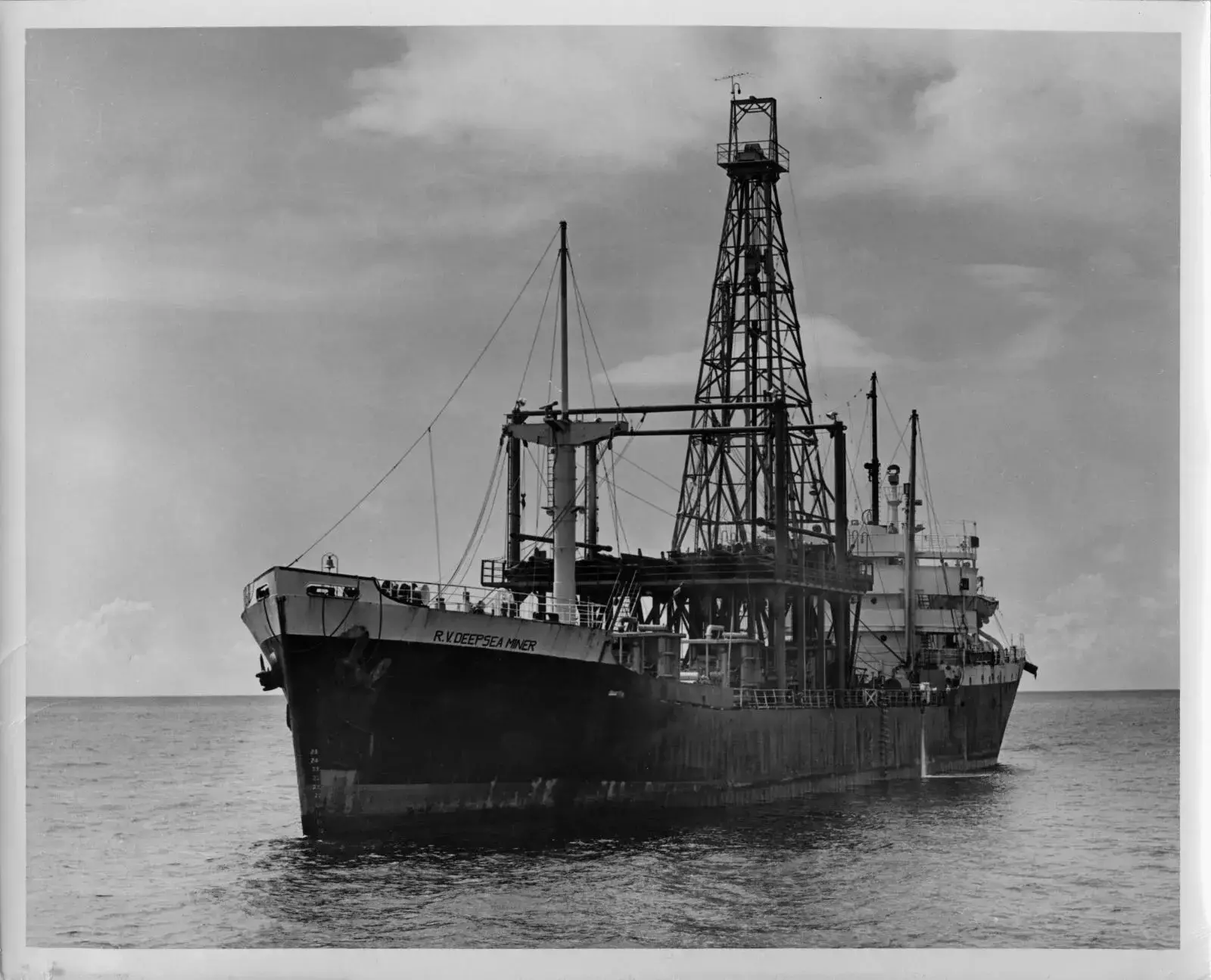
Riding the swells off the South Carolina coast, about 130 miles out, the vessel R.V. Deepsea Miner was busy sucking thousands of potato-sized black rocks from half a mile below the surface using a giant vacuum. Garside was anxious to see this up close.
The event underway on this Thursday in July 1970 marked the world’s first successful test of a system designed to mine the deep sea. A U.S. company had just spent $15 million and nearly eight years chasing a dream once thought to lie only in the realm of science fiction.

As a nonprofit journalism organization, we depend on your support to fund more than 170 reporting projects every year on critical global and local issues. Donate any amount today to become a Pulitzer Center Champion and receive exclusive benefits!

The potential profits to be made stood in the billions.
Garside had no interest in the prospective windfall. His concerns lay with the fish and microscopic life swirling above and how they might be impacted by the mining underway on the Blake Plateau. This underwater terrace extends from Florida to South Carolina. Canopied by the Gulf Stream, a rich ecosystem teeming with understudied lifeforms rests at its depths.
The weather would stymie Garside on this night and for two days more. By the time he reached the site, executives with the Virginia-based mining company were already touting their success. Humanity’s first attempt to airlift deep-sea metals to the surface had worked. Articles in The News and Courier and the New York Times trumpeted the achievement, noting that the process worked four times faster than expected, even in rough weather.
Organizers of the mission predicted that a fortune could be made from these dark nodules on the ocean floor. They contained valuable amounts of cobalt, nickel and manganese — minerals critical to powering fighter jets during the Cold War.
Garside, though, envisioned catastrophe. For the next three years, he labored on a book that sounded some alarms about deep-sea mining. He and six others contemplated the release of toxic microbes from deep-sea muck, destroying undescribed deepwater habitats and disorienting entire fisheries with mud plumes the size of Rhode Island. They wrote that the race to exploit the deep sea would happen at a very large scale, in the “very near future.”
But the scientists were wrong. Deep-sea mining never made it to commercial production and still hasn’t.
The company behind the 1970 mission, Deepsea Ventures Inc., folded 20 years in. New companies emerged, but the work was always difficult, the payoff uncertain — or, as one newspaper wrote, “imaginary.” Garside, the oceanographer, died in 2003.

By that time, the deep-sea mining operation that made history off Charleston’s coast was largely forgotten, faded into footnotes.
And that’s where Jason Chaytor found it in 2016. Chaytor, a scientist for the U.S. Geological Survey, was searching through government archives when he spotted mention of the 1970 mission on a hand-drawn map.
He started daydreaming about returning to the site with an underwater robot to study the long-term effects that occur when a chaotic disturbance shocks a place and everything that lives there. The mining site, Chaytor proposed, could serve as a natural laboratory for measuring the aftermath of chaos, both natural and human-made.
He had no idea his scientific journey there would collide with the second coming of deep-sea mining.
Many countries are now pushing for full-scale seabed mining. Cobalt and nickel are essential for making the batteries that power electric vehicles. Some say mining these minerals from land alone won’t be enough to support EV supply chains, though that point is still hotly debated.

South Carolina wants to be a hub for EV manufacturing. In 2021, the sector brought in $10.27 billion to the state’s economy.
While the Blake Plateau lies in U.S. territory, the world’s most profitable nodules are found in international waters. There, a United Nations treaty has long protected them from exploitation. But if countries like Belgium, China, Russia, Tonga and Nauru succeed, it could mean that — for the first time in history — a natural resource legally classified as the “common heritage of mankind” is stripped away and sold for profit.
Most nodules lie on what scientists call abyssal plains, which form the largest and most biodiverse habitats on the planet. Some of their more resplendent inhabitants, like dumbo octopuses, are as large as house cats. Most are worms as thick as human hair.
A scarcity of scientific knowledge about these animals warrant a precautionary pause, say some countries; others are pushing for commercial-scale extraction as early as 2025.
How we fail or succeed to manage that tension will set a first-of-its-kind precedent that goes beyond the seafloor. Filmmaker James Cameron wants to wrangle asteroids. Tesla’s CEO Elon Musk is cooking up mining robots for Mars.
Conservationists are asking them and ocean mining companies some of the same questions: “How do these previously unreachable places recover from disturbance? Can they recover at all?”
One scientist’s discovery just got us closer to an answer.
Treasure at the bottom of the sea
Deep-sea mining made its debut in 1869 in the fictional world of Jules Verne’s “20,000 Leagues Under the Sea.” The idea has entranced industry titans and scientists. But, for most people, it resides in another world entirely, like trying to comprehend the birth of a star.
The rocks they seek are also otherworldly. Polymetallic nodules grow and shift about the seafloor, recording time and the ocean’s chemistry like a ship’s log. Cutting into one is like cutting into a tree. Concentric rings radiate outward, allowing scientists to tell its age and how much oxygen swirled about as it grew.

About 10 million years ago, off the coast of Charleston, the ocean swarmed with beasts. History’s largest sharks and some of its earliest toothed whales roamed what is now the Southeast U.S. continental shelf. As they passed, debris rained down to the bottom, including errant shark teeth, which joined pieces of volcanic rock scattered below. Scientists believe that these scraps started to grow in size as they slowly attracted trace metals found within the ocean’s chemical soup, forming thin coatings dense in critical minerals like manganese, nickel and cobalt.
For millions of years and in complete darkness, those rocks steadily grew in oceans around the world.
In 1872, a catch of muddy nodules tumbled from a drag net onto the sunbaked deck of the world’s first oceanographic research vessel. The HMS Challenger flew a Union Jack flag and pulled a rudimentary fishing trawl to scrape up marine life from the Pacific’s unstudied depths.
At first, polymetallic nodules were treated as objects of curiosity. Some were exhibited at German museums — the Victorian era’s version of moon rocks.
In the early 1960s, the oceanographer John Mero first popularized the idea that the nodules could be profitable. The multi-millionaire owner of the Virginia-based Newport News Shipbuilding and Dry Dock Company learned of Mero’s ideas and wanted to be the first to reach the treasure.
The company’s first attempt was on the Blake Plateau, in 1962, replicating the same rudimentary trawl-based methods the English had used. Dragging the plow-like contraption, they estimated that 10 million tons of nodules lay waiting there.
It would take them eight more years to build a sucking device that could remove nodules quickly and at scale. Along the way, the company was bought by Tenneco Inc., a Fortune 500 manufacturing company that changed the name of its deepwater subsidiary to Deepsea Ventures.
During the company’s month-long 1970s test off the coast of Charleston, a 52-man crew sucked 60,000 nodules from the deep at a speed four times faster than planned. Three weeks in, the U.S. Patent Office approved their application for the giant vacuum that was then running nearly 24 hours a day.
The technicians ended up dumping all the nodules overboard because they were low in manganese, making them less profitable. The crew returned to Charleston in mid-August and immediately pivoted their efforts westward, to more profitable nodules that lay at the bottom of the Pacific Ocean.
Deep-sea mining companies never again returned to East Coast waters.
Four years and 19 cruises later, the company claimed it could mine enough nodules from the Pacific Ocean to meet most of the military’s needs for nickel and cobalt. In a 1974 letter, the president of Deepsea Ventures secretly requested “diplomatic immunity” from then-CIA Director Henry Kissinger to extract 1.3 million tons of nodules from international waters, roughly the heft of one and a half Golden Gate Bridges. He never got it.

Publicly, the CIA told reporters that “claims on the seabed” were outside its purview. Secretly, Kissinger was using deep-sea mining for his own spy games.
That year, the CIA carried out America’s most expensive covert operation to date under the ruse that millionaire Howard Hughes had also built a deep-sea mining vessel. In reality, Lockheed Martin built the Hughes Glomar Explorer with CIA funds so that U.S. officials could salvage a sunken Soviet submarine and its nuclear-armed ballistic missiles without the enemy knowing.
The mission only recovered half of the sub, no missiles surfaced and newspapers eventually caught on that Hughes’ deep-sea mining enterprise was an elaborate farce.
But Lockheed Martin went on to retrofit the Hughes Glomar Explorer to do actual nodule retrieval. For years, the ship was a major player in mineral exploration.
No international laws governed the high seas or its depths back then. Mining exploration continued to ramp up in the Pacific until 1982, creating what one scholar called the “golden era of polymetallic nodules.”
But by the mid-1980s, the metals market slumped. The Cold War thawed. The nascent nodule business was dead in the water.
Around that time, a team from the U.S. Geological Survey visited the Blake Plateau and tried to find the spot where Deepsea Ventures first tested its mining equipment in 1970. They brought along a state-of-the-art camera to document what the site looked like a dozen years later. The team also dropped 119 numbered blocks of concrete into the depths to provide a sense of scale in the images.
Their orientation, however, was slightly off. The blocks landed in the wrong place, just one mile away, and the camera captured nothing on the seafloor that seemed like an industrial footprint. The team, interested in the area’s geology, quickly moved on to other things on their mission list.
Along the way, the scientists scooped up hundreds of nodules using an old-school dredge before sailing back to Charleston. The nodules ended up stuffed in white canvas bags and stashed in the back of a laboratory in Woods Hole, Mass.
That’s where Chaytor found them, digging around his government office building, nearly four decades later.

‘Train tracks’ at the bottom of the sea
Chaytor is a soft-spoken Australian with cuttingly dry humor, which he delivers with a half-smile beneath a thick mop of tousled hair. In 2016, Chaytor’s curiosity about history drove him toward a set of dusty filing boxes after a colleague asked if he knew anything about the Blake Plateau.
It was the largest scientific “gap” off the Eastern Seaboard, the colleague said, a giant blank space on the map, right in our own backyard.
The boxes were stacked, floor to ceiling, in the back of a warehouse the size of a small airplane hanger, where the Geological Survey stores old boats, rusted buoys and outdated equipment.
Chaytor said he found the original reports and maps from his predecessors’ 1982 expedition to the Blake Plateau, which contained a scrawled message about “Deepsea Ventures” as well as a typed footnote. But the U.S. government had kept no record of where the world’s first seabed mining had actually happened.
“I’m often the very first person to actually be seeing some of these things,” explained Chaytor, who pursued a job that would allow him to feel the elation of revealing unknown parts of the world. He had felt it off the coast of Alaska, zooming past unknown fissures in the seafloor, and near Puerto Rico, mapping its little-known deep-sea canyon. He knew the Blake Plateau held something at its depths that revealed something new — not just about nature, but our unknown footprint on it.
He started with a Google search. The first thing that popped up was a New York Times article about the Blake Plateau test. Another search hit on the company’s 1974 letter to Kissinger requesting diplomatic immunity, now an unclassified document posted on the CIA’s website. But what Chaytor really needed was a longitude and latitude, the “X” on the map.
“A lot of the people involved had passed away. ... We lost access to what happened,” said Chaytor. He spent years searching databases online without anything conclusive. Meanwhile, his colleagues at the National Oceanic and Atmospheric Administration launched a 5-year Blake Plateau mission in 2019. One of those expeditions sought deep-sea species previously unknown to science. They found over 50.
Chaytor asked the expedition team for a favor: Could they check out one location he had narrowed in on during his research about the mining site?
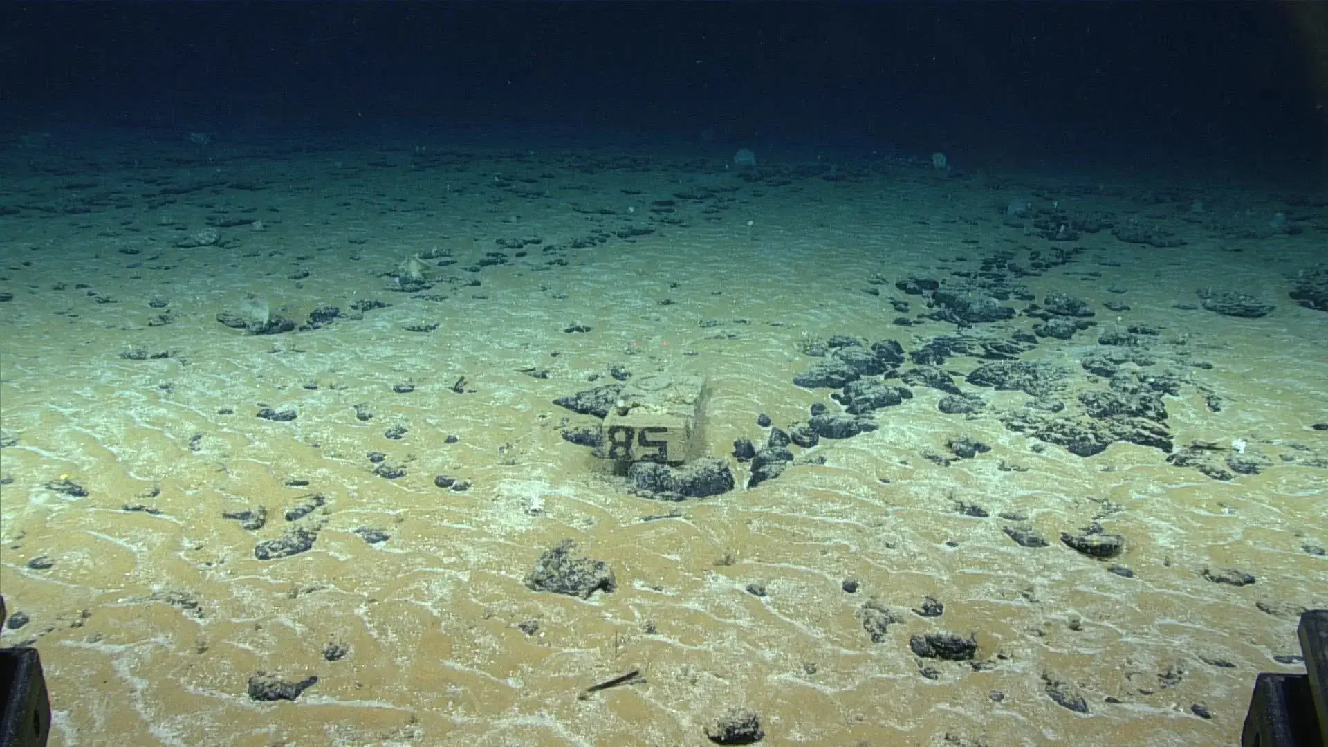
An underwater robot went down to Chaytor’s spot in early November 2019, streaming it live to Chaytor as he watched from his Massachusetts office. At first, all he could see were fields of mud and nodules. The occasional silvery cusk eel swam through. But, before the dive ended, one solitary concrete block emblazoned with the number 85 came into view.
He had successfully found the place where his predecessors had dropped their blocks. It was the wrong spot but very close to the never-before-seen test spot. His deep-sea target went from the size of Delaware to the size of a small town. This small discovery propelled him.
Later that month, he booked a flight to Newport News, Va., to search for more clues in the archive of the Mariners Museums. A miniature replica of one of Deepsea Ventures’ mining exploration vessels stood in the exhibit hall. This must be the place, he thought.
The museum’s archivist said he had no knowledge of any deep-sea mining expeditions off the coast of the Carolinas. But Chaytor went through 20 boxes of documents anyway, all donated by the widow of the company’s former chief scientist. Stuffed in folders inside one box, he found some geographic coordinates. He sensed these were the ones he had spent years looking for. But how could he be sure?
He flew back to Massachusetts and wrote up a plan to visit the site the following summer with a research vessel and an underwater drone. The Bureau of Energy and Ocean Management funded his idea, but the pandemic put his plans on hold.
Finally, in August 2022, Chaytor sailed out of Massachusetts on the Deep Helder toward the Blake Plateau.
It was the height of hurricane season, and Chaytor and his colleagues only had eight days to find something on the seafloor. They started by collecting sonar images with an underwater drone, the same type recently used by a Charleston-based company in its search for the long-lost plane flown by aviator Amelia Earhart.
After a nearly 6-hour wait, the bathtub-sized drone returned. The scientists popped the robot’s hard drive out of the pressurized compartment and waited while the data loaded. The sonar revealed fuzzy glimpses of their first clue: lines in the sand that, to Chaytor, looked “just like long train tracks.”

The lines seemed to be clear evidence of human activity.
So they sent the drone back down. This time it took pictures of the seafloor, three images per second for nearly 24 hours.
Chaytor sat in a windowless command center with two other government scientists. The trio scrolled through thousands of images.
A concrete block with scrawled numbers came into view. And then another. And another. They were in the right place. These were the same blocks tossed off the side of a boat in 1982 by Chaytror’s predecessors at the Geological Survey. In subsequent trips, the drone came back with more bits and pieces, one frame at a time.
They located dozens of the blocks, as well as images of some lines, here and there, dug in the sand.
They didn’t know how to feel about the find because they couldn’t really see anything. The scientists had to pull a discovery from the deep in snippets.
After eight days at sea, the Deep Helder called to port in Charleston. Chaytor flew back to Woods Hole, where he spent the rest of 2022 and 2023 returning to those snippets. In between other projects, he fed his computer the images from the Blake Plateau, trying to puzzle together a mosaic-style image of larger views of the seafloor.
Only through methodically piecing together a “complete picture” did Chaytor realize how little the area had recovered since that giant vacuum removed nodules a half-century ago. The areas between the long straight tracks had no nodules, no sponges, no fish, just wavy lines of sand. Outside the tracks lay giant fields of nodules, mottled, encrusted — tiny cities resting atop a geological buckshot of debris.
“It looked like they were there yesterday,” he said, referring to the 1970 seabed miners’ impact on the environment.

He wanted to share the images with other scientists as soon as possible. Perhaps then he could justify a return trip, this time with biologists and a robot with mud-scooping arms. Were the wavy lines in the sand as lifeless as they looked on his screen?
New Orleans would soon host the largest gathering of ocean scientists in North America. The conference gave Chaytor a forum to showcase the discovery, along with a deadline: Feb. 19, 2024. He vowed to make 16 more sweeping panoramic views of the test site, requiring nearly all 500,000 drone photos.
The computer churned overnight, in a darkened office decorated with his young son’s drawings and school picture. Chaytor would come in the next morning, see the latest photomosaic output with train tracks extending, sometimes crisscrossing, in all directions. In one particularly dramatic image, he could see seven different tracks in a swath of seafloor about two football fields in size.
All he could say was: “Wow.”
He didn’t expect the tracks to be so extensive, so well defined. The lines separating the ocean’s wild depths from humanity’s industrial reach were clear.
‘Dangerous gray area’
The expedition’s discovery arrived at a time when the political milieu around deep-sea mining was reaching a boiling point. After years of simmering tensions, a series of events caused the debate to escalate on the global stage, changing the way people would view Chaytor’s images.
In April 2021, a Belgian engineering firm cruised to the remote Pacific and lowered a SUV-sized rover nearly 3 miles below the surface. It marked the first successful test in more than 40 years of a pre-prototype device for collecting cobalt-rich nodules from the Pacific.
Pressure to begin mining was building again as EV manufacturing ramped up. The global market needed more than 8,000 megatons of cobalt to keep pace. But a 1994 United Nations treaty, known as the Law of the Sea, governed and protected the seabed in international waters. That treaty had been signed by 168 nations.
Among them was the island of Nauru, which had now partnered with a Canadian-based company in a deep-sea mining venture. They were anxious to get to work. So, they invoked a passage in the treaty that established a 2-year deadline for the nations to devise environmental guidelines to allow for commercial mining.
That alarmed many scientists, who said there wasn’t enough science yet to know what qualified as “sustainable” mining. A few countries called for an all-out moratorium.
Notably, the U.S. never ratified the Law of the Sea. Congressional Republicans had cautioned against signing the accord, saying it would limit U.S. power. But the move now left America without a vote in the mining debate that would affect a massive area encompassing 40 percent of the planet.
Diplomats soon set to work trying to hammer out the world’s first seabed mining code. They met online and in Kingston, Jamaica, home to the U.N. International Seabed Authority, which enforces the ocean treaty. The American delegation sat off to the side. Their name tags read “observer.”
Opting against ratification also meant that the U.S. can’t obtain a license to mine. Meanwhile, its geopolitical adversaries — China and Russia — hold 15 percent of the world’s nodule exploration licenses. The seabed authority announced that China became the largest contributor to its administrative budget the same year that the 2-year timeline started counting down.
With superpowers leaning in, Greenpeace and the World Wildlife Fund went on the offensive.
The two environmental groups lobbied car makers to stay clear of deep-sea metals. South Carolina’s two largest carmakers, Volvo and BMW, signed a pledge to not source or use them in their supply chains for the near future.
“All alternatives to deep-sea minerals must be explored as a matter of urgency,” the companies wrote in a 2021 joint statement, also signed by Samsung and Google. If they continued sourcing recycled metals and innovating battery technology, the companies said, they could make their EVs without mining the sea.
Andrew Thaler covered the global play-by-play as editor-in-chief of the Deep-sea Mining Observer, an industry trade journal. He knew that enacting the mining code could open the doors to more contractors lured by potential profits.
“Then we would see the beginning of a gold rush,” he said.
Last July, the 2-year deadline came and went with no code in place. The global community had entered what Thaler called a “dangerous gray area.”
Mining companies were suddenly allowed to apply for a license to extract deep-sea minerals without any environmental regulations in place. The seabed authority could technically permit it, creating an unprecedented commercial loophole to begin operations.
Weeks later, the Canada-based mining firm pledged to make that unprecedented move by July 2024. Experts predicted China would likely follow suit.
In December, 31 members of Congress — including South Carolina Republicans Nancy Mace and Ralph Norman — asked the Pentagon to develop a “plan” to address China’s predicted dominance in the deep-sea metals market. “We cannot afford to cede another critical mineral resource to China,” they wrote.
Lisa Murkowski, an Alaska Republican, then made an eleventh hour push to get Congress to ratify the Law of the Sea, a vote that had been largely mothballed since the Clinton administration. Despite some bipartisan support, the bid failed.
Tensions and concerns rose. How would the ocean floor fare if large-scale mining operations got underway? Could it recover from such an intrusion? And what effects would it have on the marine life below?
Unbeknownst to all but a few, Chaytor’s images held some important clues to answering those questions.

‘These are powerful’
Chaytor had spent months processing images from the Blake Plateau. So far, the expedition’s history discovery had drawn little notice. The U.S. government trumpeted the find in a three-paragraph press release posted on an agency website. Only one reporter had called him about it.
But the panoramas he had created, eight in total, offered sweeping views of the disturbed sea floor unlike anything scientists had ever been able to capture.
The U.S. Geological Survey posted a low-resolution version of one of the panoramas on its website in January. It drew little notice, even from leading voices in the mining debate.
The Post and Courier showed the image to three key figures in the debate. None had any inkling that three U.S. agencies had rediscovered and then photographed the site of the world’s first deep-sea mining test.

“No recovery. That is gruesome,” said John Hocevar, the longtime director of Greenpeace’s oceans campaign, who has logged many hours in underwater submersibles. “And it’s over 50 years ago. These are powerful.”
Hocevar seized on the idea that these images could change minds, much as photos of bloody whale carcasses had turned the public against the whaling industry years ago. He suggested pasting Chaytor’s images on the side of buildings for all to see.
But if you walked by a building wrapped with the images, and didn’t have any context, the images could seem almost unremarkable. Unlike gory whale images, those of parallel lines in the sand reaching out into the abyss don’t quite speak for themselves.
Kris Van Nijen is CEO of Global Sea Mineral Resources, a subsidiary of the Belgian dredging giant DEME. His firm conducted the April 2021 rover test in the Pacific. He agreed that past mining approaches had been terribly destructive, as Chaytor’s images showed. But the industry has made great strides, he said, rendering images of the damage caused by outdated technology less relevant today.
The old methods involved lots of “pulling and pushing,” Van Nijen said. But his firm’s rover used a more sustainable approach, puffing air under nodules to elevate them for collection as it moved along on tracks like an army tank.
Thaler, the biologist-turned-journalist, is neither for nor against deep-sea mining. But he sees it as imperative for the general public to confront how the world should approach the practice, weighing the costs and benefits of proceeding on a commercial scale. He is hopeful that Chaytor’s images will help spark such a debate while there is still time to devise ways to limit human harm. That’s not the norm.

“The traditional arc of industrial development is that we find oil in Pennsylvania. We drill as much as we can, and only 10 or 20 or 50 years later do we realize how much harm it’s done,” said Thaler. “We’ve never had an opportunity — like we have now with deep-sea mining — to go in first and figure out what those harms might be, and figure out how to mitigate them and figure out whether or not those are acceptable.”
Chaytor deflects these sorts of policy-related questions. He prefers doing the science, not speaking out or proscribing a path forward. Three months before the New Orleans conference, his presentation was relegated to a poster instead of a public lecture. Chaytor didn’t mind: “Great. Less talking for me.”
Looking back, it was the scientists who got us here: proposing the idea, building the technology, launching the instruments, cataloguing the alien-like lifeforms at risk.
Garside, the British oceanographer who first sounded the alarm about deep-sea mining, predicted a great awakening of deadly ancient microbes, released from the muck by our nodule-collecting robots. That never happened.
But much of what Garside predicted in the 1970s was verified by other scientists, steadily chipping away at these questions with each new research cruise.
Last year, researchers found that the sediment plumes created by deep-sea mining would force tuna to migrate away, disrupting the Eastern Pacific’s $40 billion tuna fishery, just as Garside had anticipated could happen in the Atlantic.

He was also on target in his estimation that it could take decades to catalogue deep-sea fauna that live close to target mining sites. Researchers last year discovered 5,000 new species in a Pacific deep-mining hotspot.
Two months ago, Chaytor’s colleagues announced that their 5-year Blake Plateau project had not only discovered dozens of new species, it had also mapped the world’s largest cold-water reef. It’s roughly the size of Vermont, and scientists had little inkling it was there. Its location is 80 miles from where the world’s first deep-sea mining test had occurred.
Garside predicted it would take “a decade or more” to catalogue this marine life. It took five.
A decade ago, European scientists working off the coast of Peru started to gather the first evidence that there may be zero recovery from industrial nodule removal within the next few decades, if not millennia.
Today, the official unveiling of Chaytor’s images put that hunch on firmer ground.
In New Orleans, Chaytor is set to stand in front of a poster in an echoing conference center hall with his groundbreaking images on display.
It’s unclear how far his discovery will resonate. Could it possibly travel from this conference center to the floor of the International Seabed Authority?
“Just because this comes out and I don’t get a whole bunch of phone calls … down the road, it still might become useful,” he shrugged. “It’s the nature of science.”
Chaytor was certain that scientists decades from now would see its value. That’s what mattered to him. For non-scientists, this unique view about human destruction in unreachable places may fade into history’s footnotes once again. Once there, it’s up to future generations to find and make sense of it.